What if a community of citizen observers could actively support scientists in monitoring the coastline through photos taken from a fixed point? This is the idea behind the Sea-Clic project, led by the Observatoire de la côte de Nouvelle-Aquitaine (OCNA), Surfrider Foundation Europe and the Centre aquitain des technologies de l’information et électroniques (CATIE). Together, they encourage local residents to contribute to coastal monitoring through the CoastSnap Nouvelle-Aquitaine citizen science programme.
The coastline of Nouvelle-Aquitaine stretches for several hundred kilometres and features a wide variety of landscapes, from sandy beaches and dunes to estuaries and river mouths. It is constantly evolving and faces multiple challenges: coastal flooding, wind and marine erosion, sand movement, shoreline retreat, as well as impacts from storms and sea-level rise. These natural processes, often accelerated by climate change, continuously reshape the coastline and pose major challenges for public safety, ecosystem preservation and sustainable coastal management.
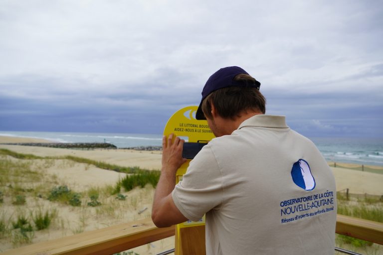
To better understand these dynamics, the CoastSnap Nouvelle-Aquitaine project was launched in 2021. Based on an innovative citizen science approach, CoastSnap stations installed along the beaches allow anyone to contribute: place your phone on the fixed mount, take a photo, and submit it via the app, by email or on the dedicated website. Since its launch, several stations have been installed along the coast, including in Lacanau, Capbreton, Saint-Jean-de-Luz, Biscarrosse, Mimizan and La Brée-les-Bains.
However, complete monitoring requires regular images, especially during storms, key moments that often go undocumented due to low beach attendance in winter. Ideally, scientists would need one image every 15 to 20 minutes during such events to refine their analyses. It is in this context that Sea-Clic is being developed.
Sea-Clic: a community of observers gathered around the Mimizan coastline
The project aims to strengthen the monitoring system by creating a group of volunteer observers responsible for taking photos of the coastline during key moments identified by scientists from the Observatoire de la côte de Nouvelle-Aquitaine.
The Mimizan coastline was selected to develop the Sea-Clic project. Since 2013, the Communauté de communes and the Municipality of Mimizan have been conducting regular monitoring of their coastal zone, which is exposed to coastal flooding as well as wind and marine erosion. Tracking sand movement is essential for anticipating risks and adapting coastal management. To enhance this knowledge, a CoastSnap observation station was installed in July 2024 on Mimizan beach.
As part of Sea-Clic, a group of citizen observers has been formed and is coordinated by Surfrider Foundation. Mobilised during key events such as storms and high tides, these volunteers provide essential images that complement field data. This will enable the Observatoire de la côte de Nouvelle-Aquitaine to access richer and more regular information, helping the Community of Municipalities and the Municipality of Mimizan strengthen their coastal management and protection efforts.
From your phone to the scientists: what happens to the coastal photos?
Once shared, the photos are added to a citizen image bank, where they are compared and analysed by scientists using algorithms developed by the international CoastSnap network and the Observatoire de la côte de Nouvelle-Aquitaine. This database is accessible on the CoastSnap Nouvelle-Aquitaine website, on pages dedicated to each station.
By repeating photos from the same fixed point over time, it becomes possible to track the evolution of the coastline: shoreline position, sand levels, vegetation changes, etc. These images help assess the impacts of waves and wind and provide essential information for adapting local coastal management.
However, image processing remains a complex task, as variations in framing and scale require realignment before comparison. This is why new algorithms are currently being tested as part of Sea-Clic, with the goal of speeding up image analysis and providing faster results to guide coastal decision-making.
If the first results are conclusive, the Sea-Clic pilot project could be expanded to other CoastSnap stations across the region.
If you pass by one of our observation stations, feel free to take a photo and share it with us!