A new CoastSnap observation station has just been installed in Nouvelle-Aquitaine, on the Embellie beach in La Tremblade, Charente-Maritime. It is the 7th CoastSnap station in Nouvelle-Aquitaine, following Lacanau, Capbreton, Saint-Jean-de-Luz, Biscarrosse, La Brée-les-Bains and Mimizan.
This citizen science initiative is part of the Observatoire de la côte de Nouvelle-Aquitaine and the local coastal management strategy led by the Royan Atlantique Urban Community (CARA) with support from the Municipality of La Tremblade.
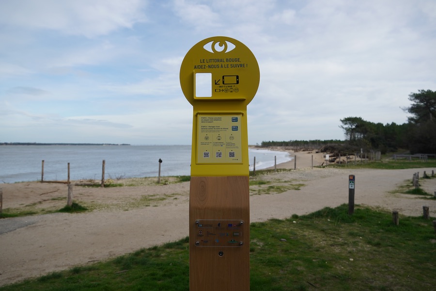
The beaches of the Royan Atlantique area are constantly shifting under the influence of wind, tides and storms, leading to significant landscape changes. This is why CARA decided to install a CoastSnap observation station at the Embellie beach site, next to the cycle path and facing northeast.
Located opposite the Maumusson inlet, the station makes it possible to observe geomorphological changes in the area, namely the study of coastal landforms and transformations, sand movement and the effects of waves and wind on the shoreline (the boundary between land and sea). The site is currently being supported through natural-process management, including dune vegetation efforts and coastal habitat protection.
Observing the Nouvelle-Aquitaine Coastline to Better Understand It
Inspired by an Australian initiative launched in 2017 in Sydney, the CoastSnap approach is based on a simple principle: from a fixed observation point, anyone can take a photo of the coastal landscape. Whether you are a local resident, a visitor on a walk, a coastal professional, a parent with children or a young person out with friends, anyone can contribute to this image collection, making it a true citizen science project.
These photos, compiled in a shared database, help track coastal changes over time while raising public awareness of the shoreline’s fragility.
The CoastSnap initiative is now deployed in many countries, including the United Kingdom, Spain, Portugal, Belgium, the Netherlands, Brazil, the United States, India, Mozambique and others, and is gradually expanding along the French coastline.
In Nouvelle-Aquitaine, the stations at La Tremblade and Saint-Palais-sur-Mer are the seventh and eighth installations, following those in Lacanau, Saint-Jean-de-Luz, Capbreton, Biscarrosse, Mimizan and La Brée-les-Bains.
How Can You Take Part in Monitoring the oastline and Contribute to a Better Understanding of this Environment?
Why not combine pleasure with purpose on your next coastal outing? When passing near a CoastSnap observation station, citizens are invited to take a photo of the beach and share it via an online form, by email or through a mobile app.
What Happens to Your Photo?
Once submitted, your photo becomes part of a citizen-generated image bank. These images are compared and analysed by scientists using various image-processing algorithms developed by researchers from the international CoastSnap network and the Observatoire de la côte de Nouvelle-Aquitaine. This database is accessible on the CoastSnap website through pages dedicated to each station.
By collecting repeated photos of the beach from the same fixed point, scientists can track changes over time in shoreline position, beach levels, vegetation and more. This information contributes to a better understanding of how these sites evolve and supports effective, sustainable beach management.
Capture how the beach evolves, share your photographs and help us better understand the dynamics of the Embellie site!
To follow changes in the coastline over time, watch our timelapse videos on social media, created from citizen-contributed photos.
The Municipality of La Tremblade committed to protecting its coastline
Faced with coastal erosion and associated risks, the Municipality of La Tremblade has been committed since 2023 to a local coastal management strategy aimed at strengthening knowledge of shoreline evolution and anticipating the impacts of natural phenomena. Embellie beach, heavily frequented by both local residents and visitors, is a key site in this approach.
To protect this fragile area, several actions are being implemented, including reducing first-line parking spaces, relocating the Vélodyssée cycle path by around one hundred metres and progressively restoring areas threatened by erosion. These measures aim to preserve infrastructure, limit vehicle traffic, protect ecosystems and raise public awareness of coastal fragility.